
Agnesa Ademin Tulevaisuus-palkinnon voittanut diplomityö käsittelee muuttuvien rajojen arkkitehtuuria
Damyn Tulevaisuus-palkinnon 2026 voitti Aalto-yliopistosta arkkitehdiksi valmistunut Agnesa Ademi diplomityöllään Reveries of a Moving Edge. Towards an Architecture of Shifting Boundaries: A Hydrodynamic Design Approach for Coastal Adaptation in Singapore. Julkaisemme Ademin työstään kirjoittaman artikkelin englanniksi. Artikkelin lopusta löytyvät tuomariston palkintoperustelut.
teksti: Agnesa Ademi
Agnesa Ademi
What does it mean to draw a line, knowing the sea will erase it?
Coastlines are often imagined as fixed boundary between land and water. In reality, they are a driven interface co-produced by currents, sediment movement, ecological successions and political decisions. Singapore is a clear example. Its coastline has repeatedly been extended, reclaimed and reconstructed. But, rising sea levels, flooding and other environmental pressures challenge the idea that this edge can simple be held in place.
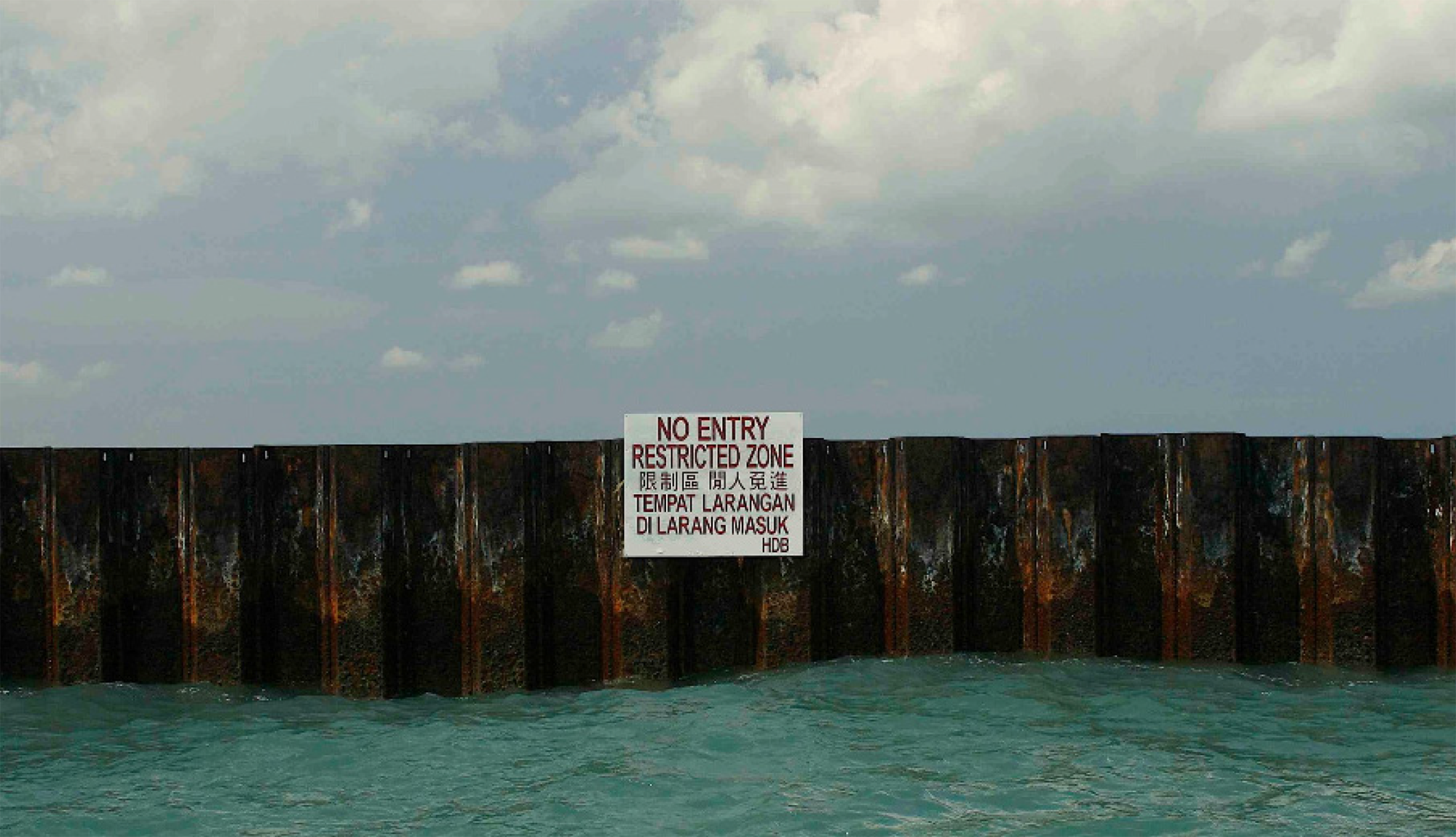
A Line in the Chart. Source: Charles Lim (2008).
Conventional design often responds by strengthening this boundary. Environmental computation is then used as a post-hoc verification tool, translating solutions that usually are manifested through hard defensive structures and massive land reclamation expansions. Yet, increasing flooding, erosion, and land subsidence revealing the limitation of this approach.
This project advances a computational design approach that treats hydrodynamic simulations as a generative instrument for spatial organization rather predicting long term morphodynamic evolutions. Rather than searching for an “optimal” form, different geometric prototypes were tested through transient computational fluid dynamics simulations to analyse water behaviour. Recurring patterns were analysed: where water slows down, where turbulence concentrates, how wakes form and persist behind objects, and where water continues to move through the system.
These persistent patterns became design information.
Based on the local flow conditions, they were translated into a flow lattice, a spatial framework derived from the movement of water through the site, connecting simulations and design. Within this framework, hydrodynamic indicators can be translated into parameters such as orientation, spacing, porosity, and elevation to produce different intervention families.
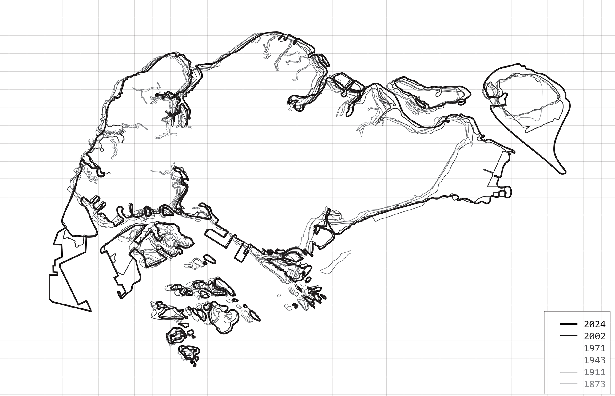
Singapore’s coastline permutations through years due to natural and cultural forces. Source: by the author.
These families are organized within a relational rule map linking high, medium, and low velocity current zones to corresponding process conditions and spatial strategies including flow redirection, sediment management, ecological establishment, aquaculture, and reservoir formation with directional dependencies and feedback shaping their interaction over time. Instead of placing the same solution everywhere, the system asks what the conditions of each place can support, treating computation as a framework for making decisions under uncertainty.
Sediment also becomes an active part of this process. Singapore continuously excavates material through underground construction and infrastructure projects. The project proposes using this material as an active agent within the system, strategically positioning it so the water can transport, redistribute and accumulate it.
The aim is not to construct a coastline once and expect it to remain unchanged. The project proposes a system that can evolve through different seasonal and decadal scenarios. Areas can grow, retreat, consolidate or be reconfigured according to environmental conditions and future priorities.
This has opened new discussion about permanence in design fields. We design, built it and we except it to remain forever. Yet climate change, rising sea levels and ecological instability challenge a culture built around prediction and permanence. Change is no longer an exception, but a condition we need to learn to live and design with.
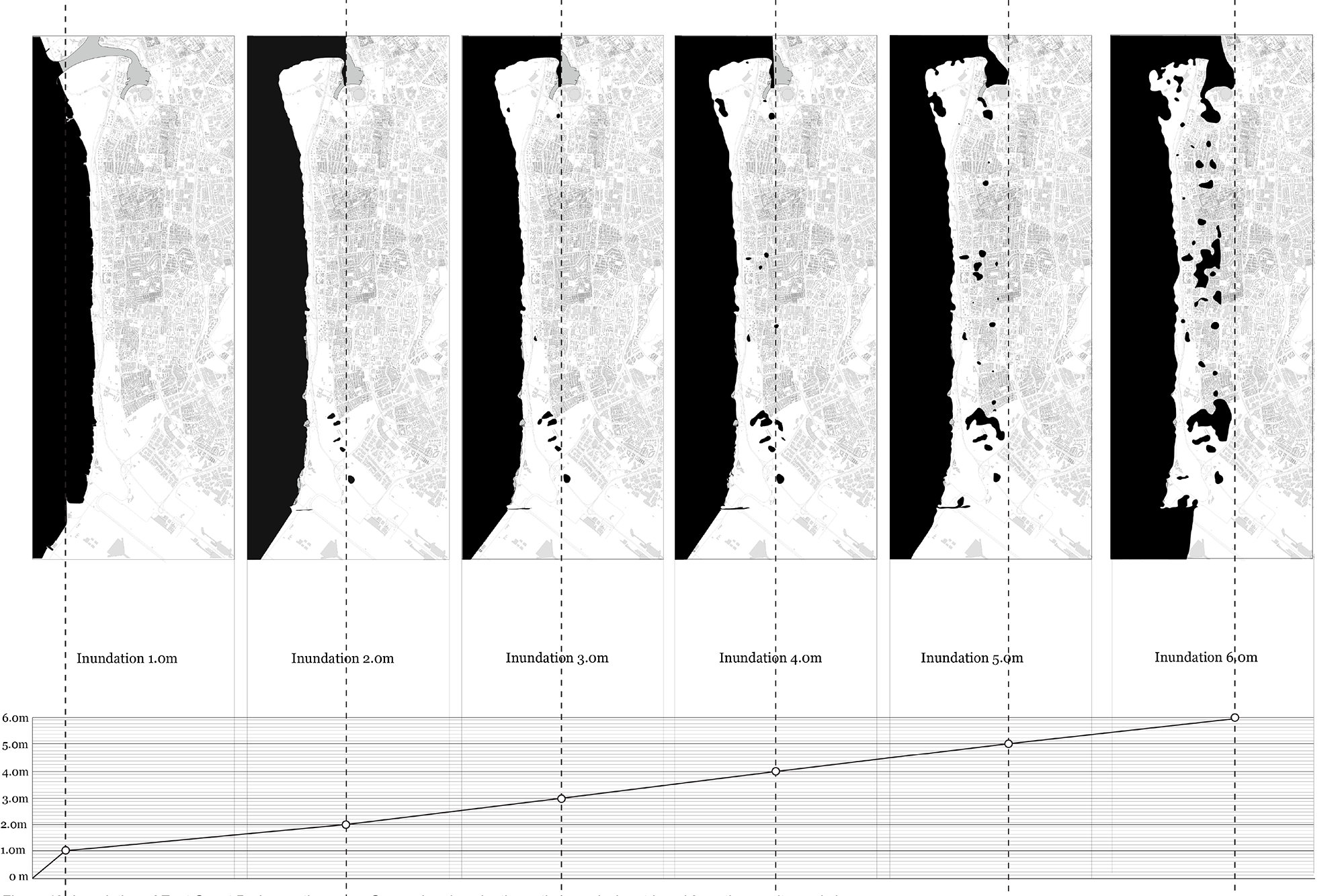
Inundation of East Coast Park over the years. Source: draw by the author, analysis retrieved from the on-site workshop.
This project has a lot of possibilities for new directions. The next step would be to develop it into a living laboratory: a small-scale intervention where the computational rules can be tested in real conditions, monitored over time and adjusted through what is observed. Instead of constructing a complete system at once, different configurations could be introduced gradually, allowing us to learn from changes in water movement, sediment accumulation and ecological development.
The living laboratory could also become a place for participation, allowing local communities to observe, use and contribute to the transformation of their coastline. Adaptation would then be developed with people and learned through real environmental change.
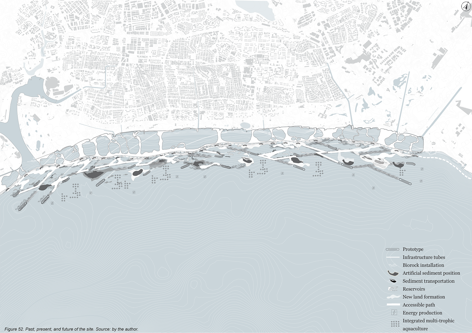
Past, present, and future of the site. Source: by the author.
Although the project is rooted in Singapore, the methodology could be explored in other vulnerable coastal territories: observe environmental behaviour, use computation to understand its patterns, translate them into design rules, and allow the design to evolve.
The project began with a simple question: what does it mean to draw a line, knowing the sea will erase it? Perhaps the answer is not to draw a stronger line. Perhaps it is to design a system that knows how to move.
Agnesa Ademi:
Reveries of a Moving Edge. Towards an Architecture of Shifting Boundaries:
a hydrodynamic design approach for coastal adaptation in Singapore
Aalto-yliopisto, Urban Studies and Planning in Architecture
Työn valvoja: Professori Pia Fricker
Tuomariston arvio
Agnesa Ademin työ on poikkeuksellisen rohkea ja innostava. Tekijä uskaltaa kyseenalaistaa yhden rakennetun ympäristön perusolettamuksista: että rannikko on pysyvä raja, joka valjastetaan ihmisen käyttöön luontoa rajoittamalla.
Työssä tarkastellaan Singaporen keinotekoisesti muokattua rannikkoa ja kehitetään työkalujen, kuten virtausmallinnuksen ja biologisten vyöhykkeiden, avulla konkreettisia vaihtoehtoja perinteisille ratkaisuille. Sen sijaan että vesi pyrittäisiin sulkemaan pois massiivisilla rakenteilla, Ademi ehdottaa porrastettuja rantavyöhykkeitä, virtausta ohjaavia muotoja ja kasvillisuuteen perustuvia kestäviä ratkaisuja, jotka voivat mukautua ajan myötä. Rantaviiva nähdään ikään kuin liikkuvana toiminta-alueena, jossa eroosio, sedimentin kertyminen ja veden liike ovat osa kokonaisuutta, eivät häiriötiloja.
Työstä erityisen vaikuttavan se, ettei tekijä jätä konseptia abstraktiksi visioksi, vaan näyttää konkreettisesti, miltä jatkuvaan muutokseen perustuva suunnittelu voi näyttää. Samalla se avaa uudenlaisen suhteen luonnon ja rakennetun ympäristön välille, jossa tavoitteena ei ole hallinta vaan yhteensovittaminen.
Agnesa Ademi
Agnesa Ademi on hiljattain Aalto-yliopistosta valmistunut arkkitehti, jolla on monitieteinen tausta arkkitehtisuunnittelussa, aluesuunnittelussa, kaupunkijärjestelmien tarkastelussa ja tutkimuksessa. Hänen kokemuksensa ulottuu Helsingistä Singaporeen ja Pristinaan, ja se kattaa suunnittelun, visualisoinnin, aluestrategiat ja kaupunkikehityksen. Hänen työskentelyssään yhdistyvät systeeminen ajattelu, kontekstuaalinen analyysi ja tietopohjaiset menetelmät. Tämänhetkisessä tutkimuksessaan Ademi tarkastelee laskennallisia simulaatioita mukautuvien, muutosjoustavien ja paikan erityispiirteisiin vastaavien suunnitteluratkaisujen tuottamisen välineinä.